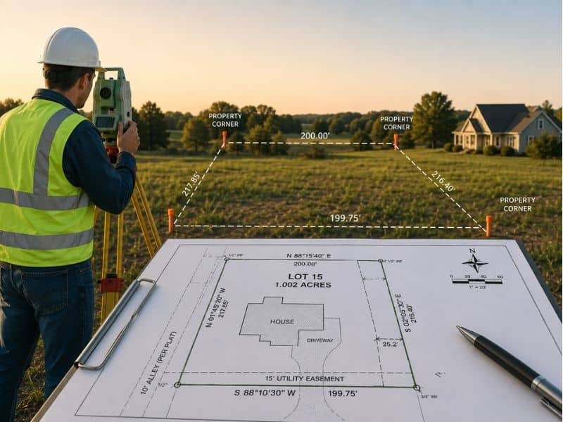
A boundary survey answers some of the most practical questions a homeowner faces before replacing a fence. Where does the property line sit? Does the planned fence cross into a right-of-way? Does the lot have any recorded rules about fence height or placement? A fence replacement looks simple, but several of those questions don’t have reliable answers without a survey. Asking them before work begins prevents problems that are much harder to fix after posts are already in the ground.
How a Boundary Survey Connects to Fence Permit Requirements
Many fence replacement projects require a permit before work begins. Permit applications usually ask for a drawing that shows where the fence will sit in relation to the property line. Without a survey, that information is a guess. With a survey, it’s a documented measurement the permit office can review.
Some permit offices flag applications when the fence sits too close to the boundary or when the lot dimensions don’t match the recorded size. Those flags slow things down. Sometimes the homeowner has to get a survey anyway before the permit moves forward. Getting the survey done before submitting saves that delay and gives the permit office what it needs from the start.
Why a Boundary Survey Checks for Right-of-Way Conflicts
A right-of-way is a strip of land along the edge of a property set aside for public use. Road work, sidewalks, and utility lines all run through rights-of-way. The problem is that a right-of-way often sits inside what looks like the front or side yard. The grass gets mowed. The area looks like private land. But a fence built inside a right-of-way can be ordered removed when that strip is needed.
A boundary survey shows where the legal property line sits and where any recorded right-of-way begins. For a fence replacement, that line matters because the fence needs to sit on private property, not inside a public right-of-way. Knowing where that line falls before the contractor arrives prevents a removal order later.
How a Boundary Survey Helps on Corner Lots
Corner lots have two street-facing sides instead of one. That creates different questions for fence placement than a standard lot faces. Each street-facing side may have its own setback rule, its own right-of-way width, and its own rules about how tall a fence can be near an intersection. A fence that works fine along the rear of the lot may not be allowed in the same form along either street-facing side.
A boundary survey on a corner lot shows where all four boundary lines sit, including both street-facing lines. That gives the homeowner accurate measurements on every side of the property. It also shows how close the planned fence sits to each line, which matters when local rules set different distance rules for front, side, and rear fences.
What a Boundary Survey Reveals About Deed Restrictions on Fences
Some properties have deed restrictions that limit what kind of fence can be built, how tall it can be, or where it can go on the lot. These restrictions are written into the recorded deed or into subdivision documents filed when the neighborhood was first platted. They don’t always show up in a quick search, and they don’t go away when the property changes hands.
A boundary survey doesn’t pull deed restrictions on its own, but the process of ordering a survey usually involves a review of recorded property documents. That review often surfaces restrictions the homeowner didn’t know about. Finding out a subdivision rule limits fence height to four feet before a six-foot fence gets ordered is a much better outcome than finding out after. The survey process creates a chance to catch those details early.
How Fence Contractors Use Boundary Survey Information
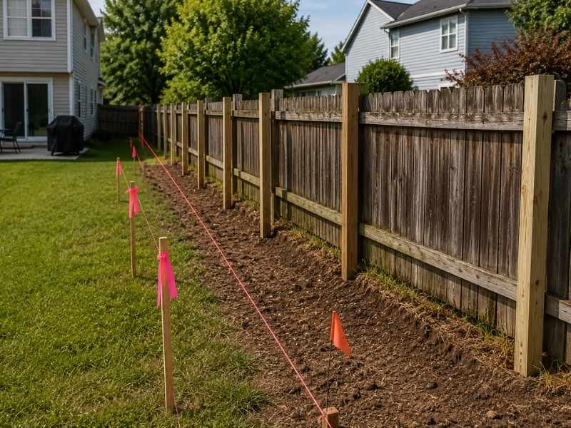
A fence contractor needs reference points on the ground to install a fence in the right spot. Without them, the contractor has to guess the line based on what looks right. That guess can be off by several feet over a long fence run. With survey stakes marking the boundary at set intervals, the contractor has fixed points to follow from one end of the fence to the other.
Survey stakes put the legal property line on the ground in a form the contractor can use. There’s no deed to read or plat to calculate from. The contractor follows the stakes. That process works the same way regardless of lot shape or fence length, and it removes the most common cause of fence placement errors before any material goes into the ground.
Frequently Asked Questions
Can a boundary survey show if an old fence is in the wrong place?
Yes. A boundary survey locates the legal property line through field measurements and recorded documents. Comparing that result to where an existing fence sits shows whether the fence matches the legal boundary or sits off to one side.
Does a boundary survey help find property corners?
Yes. A boundary survey locates the corner markers that define the edges of a lot. Those corners give a fence contractor verified starting and ending points instead of relying on estimates or visual judgment.
Should I get a boundary survey before building a new fence?
A boundary survey before fence replacement gives the homeowner accurate boundary information, helps with permit applications, reveals any right-of-way conflicts, and gives the contractor survey stakes to follow during installation.
Can a boundary survey help solve fence questions with neighbors?
Yes. A boundary survey produces a licensed, documented result based on recorded deeds and field measurements. That gives both neighbors a factual reference for the boundary rather than relying on competing assumptions.
Why do old fences sometimes end up in the wrong place?
Fences are often built without a survey, based on the owner’s best estimate of the line. Over time they can shift or get rebuilt slightly off the original position. Each replacement without a survey can move the fence further from the legal line. A boundary survey finds where the line actually sits regardless of where the fence ended up.