How LiDAR Mapping Helps Detect Hidden Drainage Problems
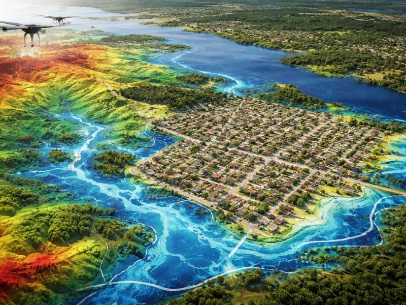
Water problems often stay hidden until they become expensive. A site may look flat and dry, yet small changes in elevation can cause standing water, erosion, or drainage failures. LiDAR mapping gives developers a clearer view of the land before construction begins. It can reveal low spots, hidden channels, and other features that are hard to see from the ground. Finding these issues early helps prevent costly changes later.
Why Drainage Problems Are Hard to Spot
Surface Conditions Can Be Misleading
Grass, brush, and uneven ground can hide areas where water collects.
Small Elevation Changes Matter
Even a few inches can affect how water moves across a site.
Problems Often Appear After Construction Starts
Poor drainage may not become obvious until heavy rain exposes weak areas.
How LiDAR Mapping Helps Detect Hidden Drainage Problems
LiDAR Creates Detailed Elevation Models
The technology measures the ground surface with a high level of detail.
Hidden Low Areas Become Easier to Find
Depressions and uneven terrain can be identified before grading begins.
Natural Water Flow Patterns Can Be Seen
Developers can understand where water is likely to travel during storms.
Drainage Issues LiDAR Mapping Can Reveal
Areas Prone to Standing Water
Low sections may trap water after rainfall.
Hidden Swales and Drainage Paths
Older drainage channels may still affect a property.
Erosion-Prone Slopes
Steep areas can create runoff problems if they are left untreated.
Surface Features Covered by Vegetation
Dense tree cover may hide terrain changes that affect drainage.
Why Developers Use LiDAR Mapping Before Construction
Better Site Planning
Early information helps avoid redesigns.
Lower Construction Costs
Fixing drainage issues on paper costs less than fixing them in the field.
Improved Stormwater Management
Knowing how water behaves helps support drainage design.
Projects That Benefit From LiDAR Mapping
Residential Developments
Large subdivisions often require careful grading.
Commercial Sites
Parking lots and buildings depend on proper drainage.
Industrial Properties
Large paved areas increase runoff and require planning.
Road and Utility Projects
Changes in elevation affect drainage systems and water movement.
Common Mistakes Developers Make
Assuming the Ground Is Flat
Appearances can be deceiving.
Waiting Until Water Problems Appear
Corrections become more expensive after construction begins.
Ignoring Existing Drainage Patterns
Water usually follows paths that have formed over time.
Why Early Site Information Matters
Hidden drainage issues can delay projects and increase costs. LiDAR gives developers a better understanding of the land before work starts. With more accurate elevation data, teams can make better decisions and reduce the risk of future drainage problems.
Frequently Asked Questions
What is LiDAR mapping used for?
LiDAR mapping is used to create detailed elevation models that help identify terrain features, drainage paths, and changes in ground elevation.
Can LiDAR mapping find drainage problems?
Yes. It can reveal low areas, slopes, and natural water channels that may affect a project.
Does LiDAR work in wooded areas?
Yes. LiDAR can collect ground information even when trees and vegetation cover the surface.
Why do developers use LiDAR mapping?
Developers use it to understand site conditions and reduce the chance of expensive changes later.
Is LiDAR mapping useful before construction?
Yes. Early site information helps with grading, drainage planning, and project design.